This trip followed laying out one of the best laid plans ever
Thursday 8/17
I plan to leave home at 0400 and drive about 4 hours to the Santanoni gatehouse parking lot near Newcomb, NY on route 28N. From there I will hike on trail #135 3.6 miles to the junction with trail #136; then left (~W) on #136 1.2 miles to the lean-to on the south shore of Newcomb Lake and get more water. Then I will continue on #136 another .7 miles to the junction with trail #137; then on #136 another 2.8 miles to the junction with trail #138; then NW on #138 .5 miles to a junction with a side trail (L) to 2 campsites; continue (R) on #138 1.4 miles to cross Ermine Brook; then continue on #138 3.7 miles to junction with trail #134. Left at this junction (W) .8 miles will place me at the (2) Moose Pond Stream lean-tos for the night. 14.7 miles hiking, about 7.5 hours, should arrive for night about 4-5 p.m.
Friday 8/18
Hiking E on trail #134, 0.8 miles back to trail #138 junction; continue on #134 5.6 miles to the Northern lean-tos; then 2 miles to junction with trail #129 (NLPT) and try to cross the Cold River. Right 0.9 miles on #129 to Duck Hole for the night, 9.3 miles for the day or about 5 hours hiking. Alternative is to continue to Bradley pond lean-to (trail #128) another 3.8 miles, or about 2 hours.
Saturday 8/19
If I wake up at Duck Hole, hike 3.8 miles on trail #128 to the Bradley Pond lean-to and make camp. Either lounge or select one of the Santanoni peaks to dayhike to. If I wake up at Bradley Pond, then I may try several of the peaks. I may hike south on trail #128 and pick a tent site near the trail #128 trailhead for the night, or just spend it at Bradley Pond.
Sunday 8/20
If at Bradley Pond, hike S on trail 128 4.4 miles to the trail head; then 2 road miles to main road junction; then 6 miles S to Route 28N; then 5 miles W on route 28N and .3 miles north to the Santanoni gatehouse trailhead. Then drive home after 17.4 miles hiking. Options are: 13 miles road hiking if night spent near parking lot; stowing pack near parking lot and running/walking to car, then driving to parking lot to pick up pack.
Like all good plans, however, it went astray, and here is what actually happened
Thursday 8/17
I left home a little after 0400 and drove to the Santanoni gatehouse parking lot near Newcomb, NY on route 28N. I got there in less than 4 hours, and there were quite a few cars in the parking lot. But I got going about 0800 like I planned. I put on my rain gear since it was misting, and it had either rained or there was a heavy dew. The trail (#135) leaving the trailhead is really a gravel road, nice and wide.
After about 0.6 miles you come to the old Santanoni Farm, where there is an old barn with stanchions and a silo, and an old milkhouse, and several other buildings. I photographed these on the way out. There you cross some nice moss-covered stone bridges. Of course, the sun came out and I warmed up, so I stopped and took off the rain gear.
I hiked on trail #135 3.6 miles to the junction with trail #136; then left (~W) on #136 1.2 miles to the lean-to on the south shore of Newcomb Lake. At first I didn't think the turn-off was the correct trail, because I thought I had a little farther to go. But I decided that must be it, because there are no other trails in the area. And after a few minutes, I was sure, since the trail was steep, narrow and very wet, like the guide book said. I stopped and put my rain gear back on to stay as dry as possible. The trail down to the lean-to is fairly steep. I met a large group there - an extended family (some from Oneida, some from Vermont, and Miami) who comes to this spot every year and spends several nights. They have a teamster haul their equipment to the lake from town, then they canoe it into this campsite. The lean-to was full of all their food and gear, and they had several tents and awnings up. They were very nice, and gave me a cup of tea while I applied treatment to forming blisters on both heels, pumped another bottle of water, and ate some snacks. I lingered here nearly an hour. They said it had rained every day for at least three days. A mistake I made here was using Spenco knit bandages instead of moleskin.
Then I continued on #136 another .7 miles to the junction with trail #137 - although I never noticed the trail from the north side of Newcomb Lake juncture. I did cross a narrow bridge over a deep inlet to Newcomb Lake at the West end, and then through a very deep and very marshy swamp on all sides of the narrow trail. Someone without perfect balance would have gotten very wet.
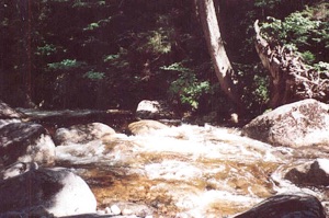
Then on #136 another 2.8 miles to the junction with trail #138, the Moose Pond Horse Trail, and NW on #138 0.5 miles to a junction with a side trial (L) to 2 campsites. I stopped here, changed socks again, took off the rain gear, and my pants legs, and decided to skip the campsites, since there were no lean-tos there. I continued on #138 1.4 to cross Ermine Brook. Only, before I actually got to Ermine Brook, I came to a very fast, very deep rushing water with no bridge. At the time I thought this was Ermine Brook, but it was actually the outlet from Shaw Pond to the East flowing down into Moose Pond. I looked up and down for a way to get across and could not see one. So, off came the boots and socks, and I waded across. The water was very cold, but I did not slip and got across. Dried off my feet with a used pair of socks and went on. I then came to a bridged crossing, which was actually Ermine Brook, but at the time I thought it was Calahan Brook. But the guide book said the gravel road ended here, and since I was still on gravel, I doubted myself. Reading further, I saw the Shaw Pond outlet, and realized my mistake - and that to my chagrin, I was about 2 miles farther from my destination than I thought. Eventually I did come to Calahan Brook, which was deeper, faster and colder than my previous barefoot crossing. This time I rolled my shorts up into my crotch and found a big stick to help keep my balance. I made it across with no falling, but the water was halfway up my thigh.
Here is a megabyte sound bite (mouthful?) of what it sounded like.
I then continued to the junction with trail #134, the Cold River Horse Trail. I took a left at this junction (W) and after 0.8 miles was at the (2) Moose Pond Stream lean-tos for the night. I got there just before 5 p.m. I had some sore feet, with blisters on both heels and both big toes were hot. Nothing serious, but noticeable.
There were two lean-tos and no one else around. Both lean-tos are very nice, and I picked the older one. The design is slightly different, and the ceiling is a little higher. Maybe this is to keep people from carving in it. The newer lean-to had square-cut timbers, and a dozen one inch pegs for hanging things from. Very nice. Each lean-to had a picnic table and a fireplace. The privy was also in very good shape.
I filtered water, called home - I got a signal in the clearing for the first time on the trip, and noticed the batteries were very low. I had a hard time hanging my bear bag - anyone watching would have been amused. There was only one good place for it, and that wasn't that good.
I dined that evening (quickly) on an instant soup and dehydrated "hearty stew with beef." Not bad, but I was bushed. I was in my sack by 7:30. It got very cold during the night, dropping to 36 by early the next morning. I put on lots of clothes and kept everything but my feet relatively warm.
Friday 8/18
I slept until after 9. That's a long time for me. Anyway, I was pretty tired, and kind of sore. I'm not in very good shape for hauling a 50 pound pack around. I decided that I'd spend the day right there. This was due to several reasons. Reading about the next planned segment, to Duck Hole, the guide said that at the far end of the Cold River Horse Trail, where it crosses the Cold River to join the Ward Brook Truck Trail and drop into Duck Hole, there is no bridge over the Cold River. The guide book allows that this can be difficult in times of high water. I decided that we were in times of high water, and I didn't feel like doing anything dangerous. An option would have been to cross the Moose Pond Stream on the bridge just below the lean-tos, hike West on the Cold River Horse Trail to Shattuck Clearing, about 2 miles, then hike East on the Northville-Lake Placid Trail, thus being on the other side of the river when the time came. This would add about 4 miles to the day's hike, bumping it up to about 14 miles. Then I would still have that long road hike from Upper Works back to Newcomb on Sunday, which was starting to disinterest me, the more my feet hurt. So I bagged the plan, and decided to stay here the day and then decide what to do.
I read a lot, and enjoyed the sunshine. I took two dips in the river, which was very cold, but I surprised myself with my ability to get in it. It was very refreshing, and there was a rock about halfway across with a sandy area next to it I could sit under water on, and keep my chest above water. I laid in the lean-to in the sun for a while. About noon I finally felt like eating, and had some oatmeal and soup. Then I went on a firewood scavenger hunt. I found lots of big stuff and carried and dragged it back. I took a little nap, thinking it would be neat to stay up late. About 7 I cooked dinner, and then lit my fire. Most of the wood was a little wet, and it took some doing to keep it going, but it got very warm. The temperature hung in around 60. About 11 I finally got in my sack, and read until past midnight.
One difference between camping near a river and camping near a lake is that you don't hear wildlife near the river - you only hear the constant rush of the water. At a lake, you hear the birds, and especially, the loons and the coyotes. But at the river, you hear the roar of the water, and the occasional seaplane or jet.
Saturday 8/19
I decided I had had my fun, and woke up around 6. I cooked water, and packed while having tea, coffee, dehydrated eggs and bacon, and oatmeal. After everything was ready, I decided another bath would be in order, since I didn't like the way I smelled. I went in up to my neck this time. Then I dressed my blister, donned my hiking attire, and off I went, leaving camp about 8.
It was a beautiful day to hike. I had decided to use the Moose Pond Horse Trail all the way back. I hoped that after a couple days of no rain that I would be able to rock-hop across the two unbridged crossings, and that was the case. I met a couple guys before I got to Moose Pond who had stayed there the night before and were heading up the Ermine Brook slide approach to Santanoni Mountain. They said there were no lean-tos or picnic tables at that campsite, just two campsites, and they were a little overgrown.
I made good time, and it was very enjoyable. I stopped at the farm on the way out and went inside the old milkhouse and took some pictures, and went down behind the barn. When I got back to the parking lot at 1:15, it was overfull. There were people waiting for my parking spot while I changed clothes. Glad I came on a Thursday.
Well, that was it. In and out. Next time I would just use the horse trail - the campsite and lean-to on the south shore of Newcomb Lake was nice, but it is probably occupied most of the time. I might go for a hike around the lake some time. The Moose Pond Stream Lean-Tos are definitely nice, remote, little used and I would go there again, but I'd skip the hiking trail and stay on the road.
The gear list and maps are shown below.